Surabaya is a port city on the Indonesian island of Java. A vibrant, sprawling metropolis, it mixes modern skyscrapers with canals and buildings from its Dutch colonial past. It has a thriving Chinatown and an Arab Quarter whose Ampel Mosque dates to the 15th century. The Tugu Pahlawan (Heroes Monument) honors the independence battles waged in Surabaya’s streets in 1945.
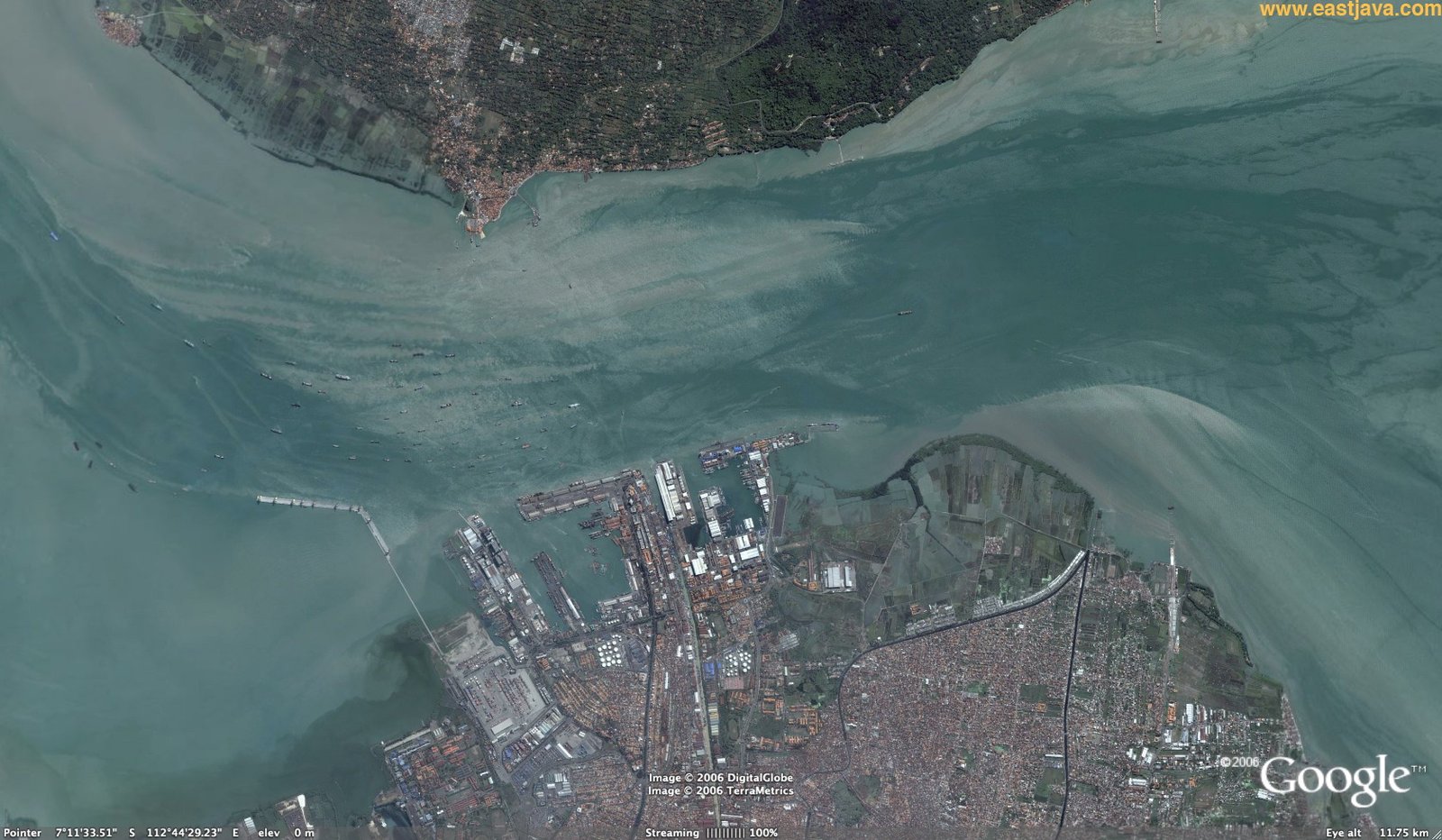
That’s what you can find, when you “google” Surabaya. But I know this city from the different side. As every seaman I know it as the Port of Surabaya, especially Madura Strait, which is a stretch of water that separates the Indonesian islands of Java and Madura, in the province of East Java and also one of the most congested anchorages in South East Asia.

And that what you get, when you have a closer look from Google Earth:

Or the real-life version from the radar screen:

In 2014, I spent 3 months staying at anchor and going outside the Strait couple of times. It took a while before I found a minute to describe my impressions and experience. And I confidently can state that it was the Experience.
With rotating tidal streams and sudden gale force winds it is really different from common quietness and relaxation of a long term roadstead.
And the picture below wasn’t just a joke. It was a day-to-day reality, when you rather have vessel anchored too close and being turned by the current in such a way that it almost hits you, or you have strong wind gusts that make some sometimes really big vessels to drag their anchor and drift towards you. In both cases you have to start your engines and adjust or change your anchorage position.

It’s a whole other story on how did we monitored our position at anchor, which I’ll discuss in the next post. In this post though, I can show some of the incidents happened during our stay. No blame to anyone. I guess, any congested place have problems from time to time.
Sometimes water could get some brighter rainbow colors… As there many ships around and the current is strong you really don’t want to claim it as yours : )
 Another day I came on my usual 4 am watch, had a coffee, it was still dark. At 5 am I had a look outside the bridge window to the quay side, there was a small cargo ship loading. At 6 am, when bosun came to have a usual day planning meeting, I looked there again and imagine my surprise…

It wasn’t exactly a vessel from the picture. But this other vessel sunk just alongside. In the following hours there was a crowd of local canoes picking up bags of floating rice…
But also, a closer look at the quay allows to see that it wasn’t the first guy, you may see a wreck by the stern of the white vessel:
Another day someone hit poor yellow buoy:

Apparently it was a local container vessel leaving the anchorage without a pilot and ran aground. It sunk in 15 minutes. Crew managed to abandon the vessel right after grounding, no casualties were reported, so far.
As we were heading outside Madura Strait we met one more vessel not under command and anchored right in the channel:
And one more bulk carrier aground at the entrance to the channel:
I must admit, it was a busy day for the port authorities and rescuers.
When I was preparing this post I found out that, unfortunately, that wasn’t the last case of vessel sinking in the Strait. On 16-Nov-2015 a ferry KM Wihan Sejahtera with 175 passengers onboard. As per maritime-connector.com the ship started getting water inside and decided to return to the terminal, but got large list to starboard and sank on the way back. Some survivors said that they felt the stroke before vessel started to list… which means that the ferry possibly ran aground.
Here are some of the pictures taken at the time of the incident.


If you have a closer look at Madura Strait navigational charts, there are many wrecks around. And these are only which were timely reported. I would say that vessels visiting such kind of areas should always take all possible measures to ensure navigational safety. Perhaps, it is a bad idea to navigate within Madura Strait without a pilot. And it helps sometime to follow the same safe tracks recorded on ECDIS from previous voyages or at least follow a ship with a deeper draft, if there is one, as you cannot really fully rely on information neither from ECDIS nor from paper charts.


Comments